Nothing "important" here... but I hope it will be seen by someone who hasn't, until now, seen a map that piqued curiosity. I hope to illustrate how fascinating a simple map can be, when you look at it carefully.
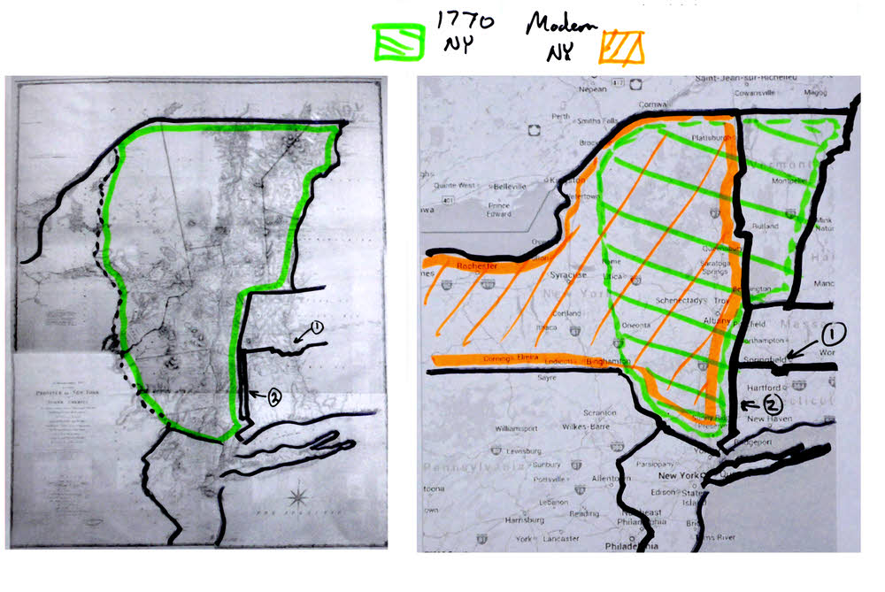
In 1779, Claude Joseph Sauthier created a map of New York, as it was in about 1770. It had a rather splendid description: "Chorographical Map of the Province of New York, divided into Counties, Manors, Patents and Townships." I was lucky enough, courtesy of Peter Harrington Rare Books in London, to have a nice visit with an 1849 lithograph of the original map, and be permitted to photograph it. I regret the shortcomings in my images, but I hope that they will suffice to enable you share my enjoyment some of the things I was struck by when I examined the map.
The map showed "New York". Not yet a state, of course, but on its way to becoming one.
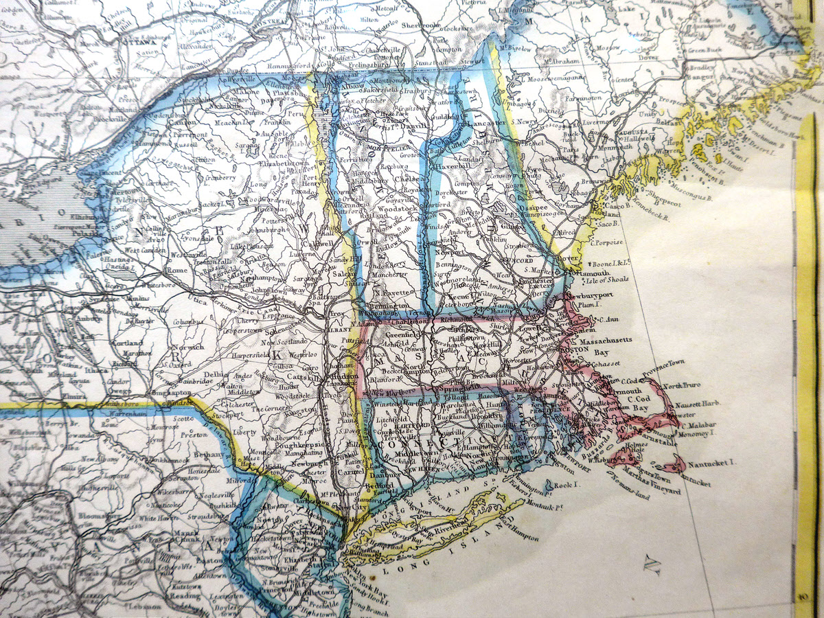
The Sauthier map is on the left, below. On the right is a map of the present day. I've transferred the Sauthier borders to the modern map, to facilitate comparison.
Continuing my discussion of the two maps above....
It is not, perhaps, surprising that the western part of today's New York was still "unclaimed" in 1770. But look at the upper eastern part! Who would have thought that Vermont started as part of New York? And when, how, why was Vermont split off? Curious, don't you think?!
Now run your eye down to the border between Connecticut (the lower state) and Massachusetts... I've marked the bit I found interesting "1"...
I'm sure that there's a fascinating story behind the little "notch" missing from modern day Connecticut... I'd known about the notch for some time. I didn't realize that historically, there was a wider "dip" in the border. I believe it arises in connection with the major river, and a large town on the river, in that region.
It will be more clear in images further down the page, but also note the odd feature at the western side of Connecticut. It is labeled "The Oblong" on the old map. Were there two views on where the western edge of Connecticut should be, and the poor "oblong" was in limbo?
Let's move on...
When I first saw the Sauthier map, I was very puzzled by the size and shape of Long Island... long narrow bit of land extending east and west, outlined in yellow, below. (The colors in that map are in the one for sale at Harrington's, by the way.)
Long Island looked all wrong to me. It seemed to be about half the length it should be... which seemed very strange, for a map drawn so carefully in other respects... and in a map drawn relatively "recently". This is not notes by Columbus, after all!
It turns out that the map is not wrong, and I'll tell you how I went wrong in a moment, after you've had a chance to look at the old map and a modern map.
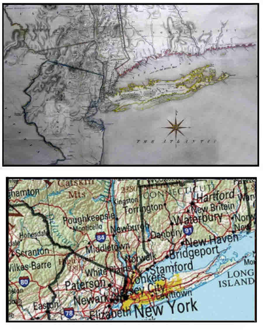
(My thanks, by the way, for the lower map, to http://www.statemaster.com)
Why does Long Island look so short in the old map?
I went wrong for two reasons...
1) I must admit that my grasp of just how large New Jersey is was weak. (New Jersey is the state in which Paterson and Newark lie.) As I thought it was "small", with its borders being so clear on the old map, to me, Long Island looked "small".
2) In the old map, the eastern border of Connecticut is not shown. I knew that Long Island stretches about as far east as Connecticut extends. When I saw Long Island ending before an eastern border for Connecticut, instead of realizing that the eastern border just wasn't shown, I jumped to the wrong conclusion, and thought it must be that Long Island was "under reported", rather than realizing that Connecticut was "over reported".
I wonder if, as Vermont was carved out of New York, whether Rhode Island was carved out of Connecticut? (Rhode Island, today, is the state to the east of Connecticut.)
Moving on, again...
Not only is the artwork in this poor, but the text is pretty chaotic, too. Earlier, I talked about the "notch" in the top of Connecticut, and the curious "Oblong" along the western border in 1770.
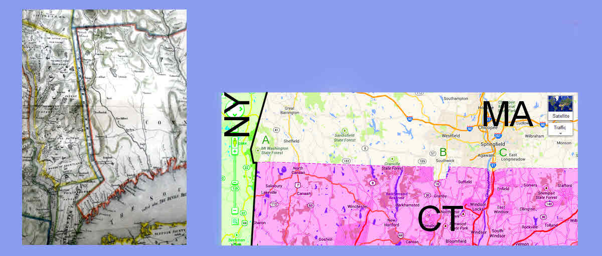
The images below give you a closer look at 1770 and modern New York, Massachusetts (MA) and Connecticut (CT).
The image of the old map gives you a better idea of how gorgeous the map is. (I have boosted the saturation of the coloring of that map, to help you see them.)
First, have a close look at "The Oblong", that curious narrow strip along the western edge of Connecticut.
The same feature appears in a map of New England dated 29 November 29th, 1774. (Not illustrated on the page you are reading.) I saw it online in a catalog (.pdf) from William Reese and Co, New Haven, CT. (Item 5) If I read the description correctly, the map in the catalog was printed in London by Thomas Jefferys, having been created by Braddock Mead. (Mead was quite a character. By this time in his life, he used the alias "John Green".) It is the third edition of the map.
Then look again at the shape of "the notch" then and now.
As I said, I knew long ago of the "untidy" "notch"... but I hadn't realized that the rest of the northern border is not a straight line!
Over at the left hand end, although it is hard to see, the line bends down slightly, just below the green "A" I've included. In the same area, look how complex the lower left corner of Massachusetts is!.
Then look closely at the part of the Massachusetts/ Connecticut border just east of the notch, under my "C". It seems that another vestige of the old, broader, "dip" persists to this day, in addition to the clear "notch".
At this point, I would like to repeating my apologies, not least to Harrington's, for the poor quality of the images... but I hope that in spite of the quality issues, these little musings were still of some interest?
Since initially creating the material above, I seem to keep coming across maps including the NY/ CT border. In hopes that you, too, will find them interesting, here. is another.
This map by T Etting, from about 1860 first caught my eye, because I thought it showed a "wiggly" western border for Connecticut. It turned out that this was just a little carelessness by the colorist, but I include the map anyway. Don't (as I did!) confuse the place marked "New City" for the city of New York, which is also on the map.
Note how the "v", or "notch" in Connecticut's northern border is missing.
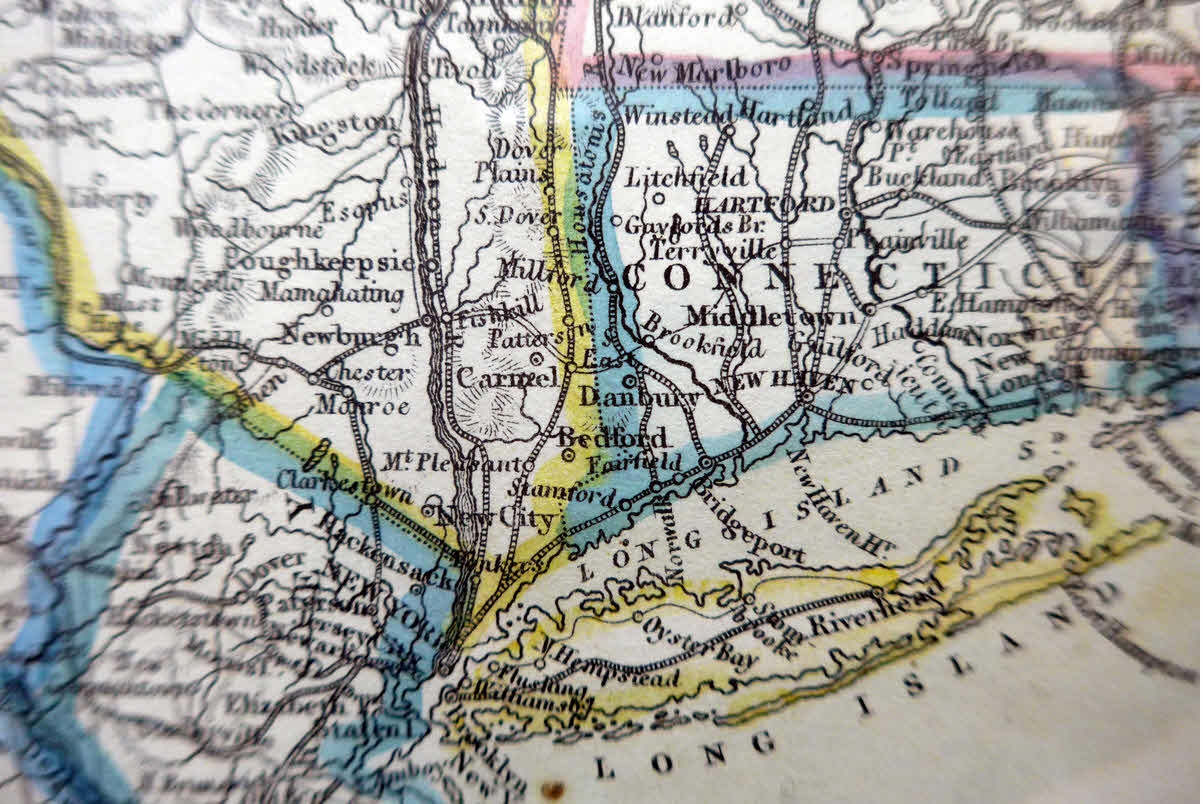
Here's a broader image of the same map...
(That image is also available in a high resolution version, which will open in a new tab or window.)
The following is a close-up of a bit of a 3.5 foot globe, created in about 1688, by Vincenzo Coronelli, in Venice. It is a stunning object (at the museum of the University of Bologna) which I was lucky enough to see on a very well conducted trip to Parma and Bologna with Cornell's Adult University.
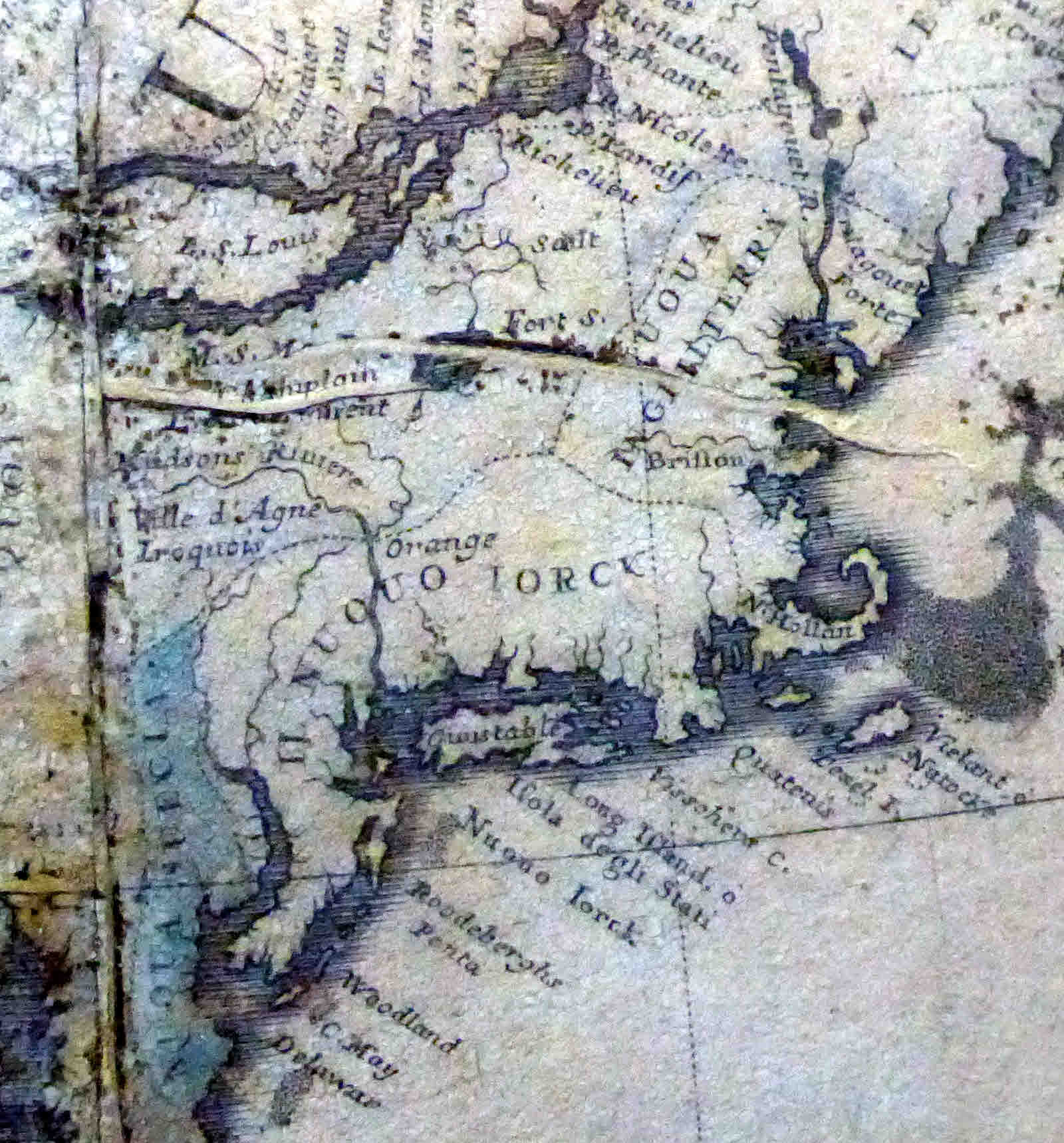
There are any number of things in the above which amused me; I hope you will find your own.
I believe it is "Nuouo Iorck" ("Nuevo York", "New York") across bits of modern New Jersey, New York and Connecticut. "Long Island" seems to be marked as such, in English, on an Venetian map. Long Island also referred to, I think, as "Isola degli Stati"... "Island of the...?".
Cape Cod then known as "N. Hollan"... New Holland?... and at the south-east end of a rather small "(N)uoua Inglillterra"... "New England". Where modern Boston is, "Briston". Natucket marked "Nytock".
"Orange" appears not far from modern day Orange CT. Where modern Cape May is, "C. May".
Have fun finding your own items. The globe created about 1688, remember.
(That image is also available in a high resolution version, which will open in a new tab or window.)
Search across all my sites with the Google search button at the top of the page the link will take you to.
Or...
Search just this site without using forms,
Or... again to search just this site, use...
The search engine merely looks for the words you type, so....
*! Spell them properly !*
Don't bother with "How do I get rich?" That will merely return pages with "how", "do", "I", "get" and "rich".
I have other sites. My Google custom search button will include things from them....
One of my SheepdogGuides pages.
My site at Arunet.
This page's editor, Tom Boyd, will be pleased if you get in touch by email.
![]() Page has been tested for compliance with INDUSTRY (not MS-only) standards, using the free, publicly accessible validator at validator.w3.org. Mostly passes.
Page has been tested for compliance with INDUSTRY (not MS-only) standards, using the free, publicly accessible validator at validator.w3.org. Mostly passes.
AND passes...
