 Bookmark this on Delicious
 Recommend toStumbleUpon
I started with the region around what we now call "Victoria" when I embarked upon trying to infect you with my fascination for what the Cruchley maps can tell us of the history of London. Of course, at the time of the earliest Cruchley maps, with Princess Victoria only nine years old, the area did not yet have this name. (I say "started"... at the moment this is the only area I've delved into in detail, but if reaction is positive, I will try to investigate other areas.)
This page is a sub-page related to my main page about Cruchley's maps of London in the 1800s.
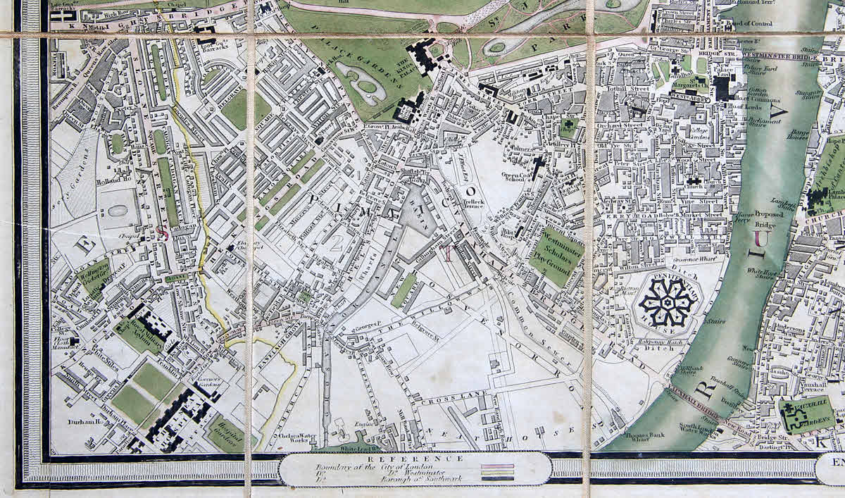
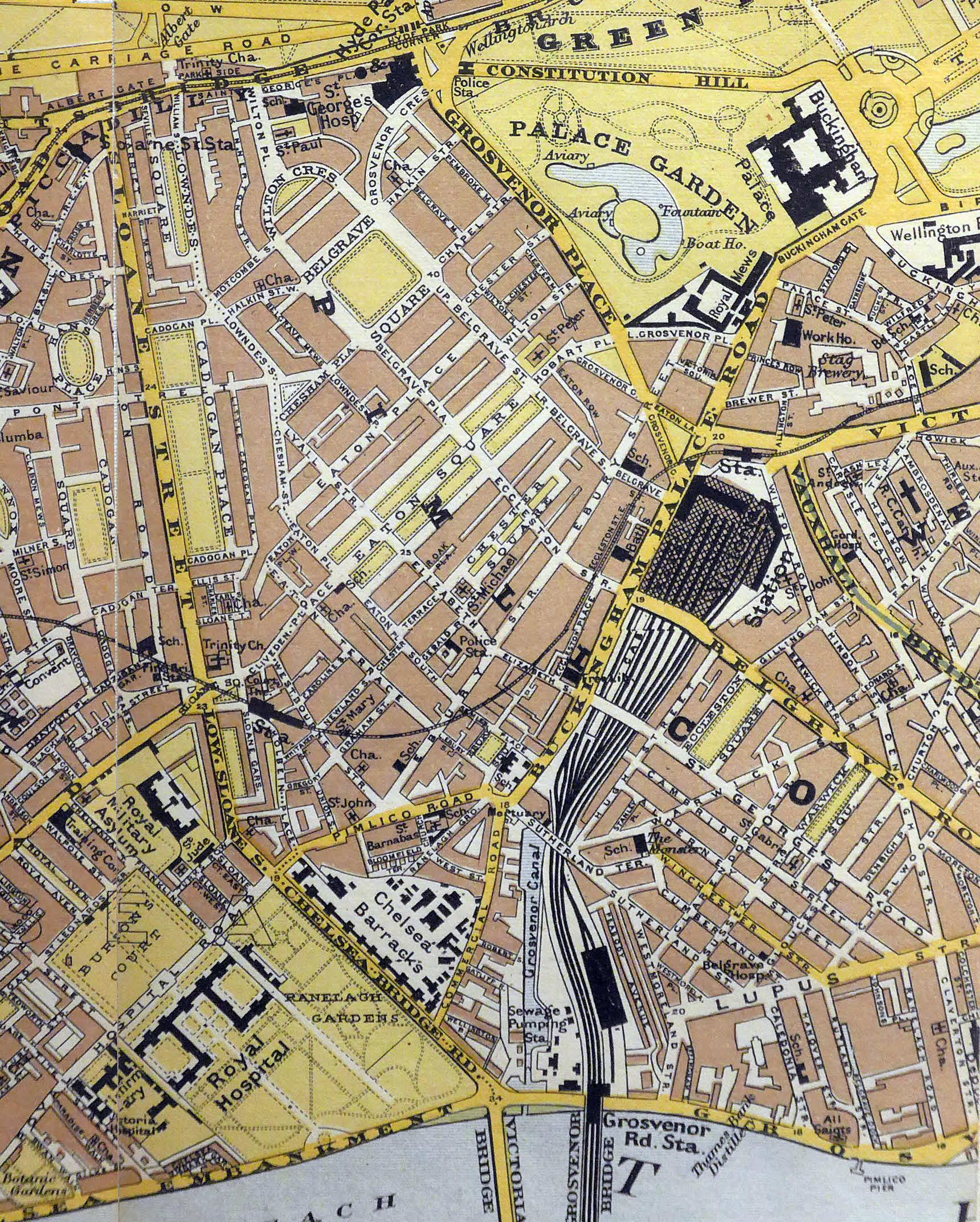
Here, chosen more or less at random, is a close up. The whole map is 93 cm x 44 cm, measured inside the decorative border. The portion in the image is 26 x 15cm.
This page has a way to go... but maybe the following, which I intend to expand in due course, will amuse...
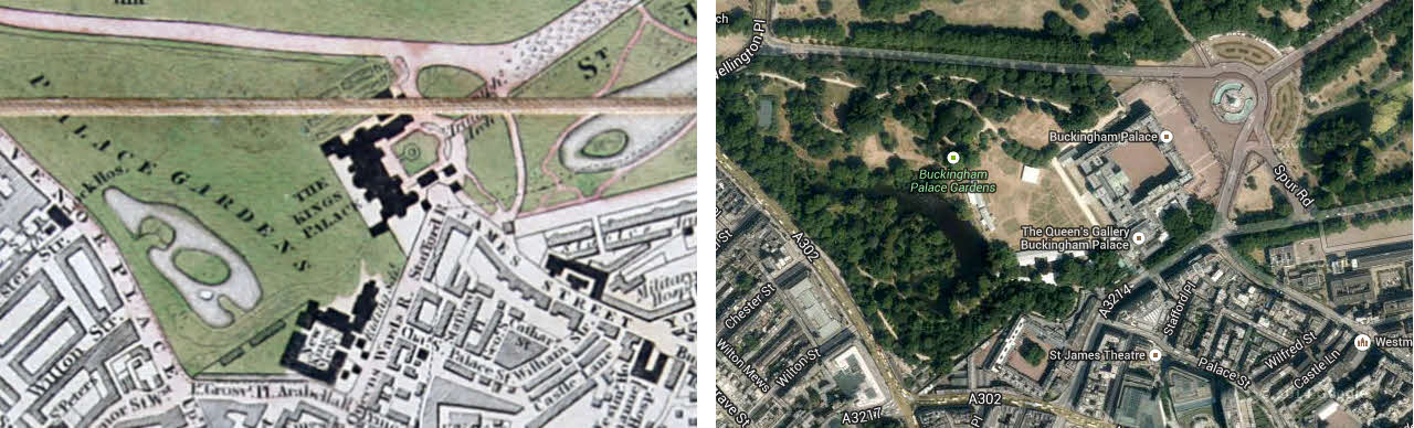
See how the Palace has changed? What we think of as the front, including the famous balcony, wasn't completed until 1850. (The present "look" was applied in 1930.)
While it may be identified as "The King's Palace" (sic... the final e is an e on the map, despite what it may look like here), Wikipedia says that Queen Victoria was the first monarch to reside there. (I will be interesting to see when the label on the palace changes on the Cruchley maps. Victoria came to the throne in 1837.
Continuing the King's Palace/ Queen's Palace theme: George III bought it in 1761, but though it was his, it was then known as "The Queen's House", as it was for his wife. I always think it a bit sad when healthy spouses have separate bedrooms... but separate houses?
The pond in the Palace grounds changes from Cruchley to Cruchley... shedding an interesting light on either his privileges of access, or the general public's access in those days. Speaking of access, notice how the roads to the SE have been pushed back from the palace.
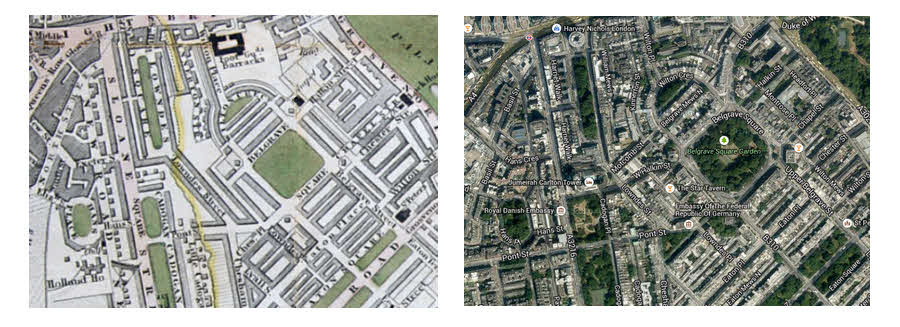
Just to the left of Buckingham Palace, the region of geometrically laid out streets is Belgrave Square. They look quite different in an earlier map. I will try to show you the alternative form in due course, but for now here's a "Then and Now" pair.
The image on the left has had some help from photo manipulation software (PhotoPlus), but only to remove the gaps which were present between panels.
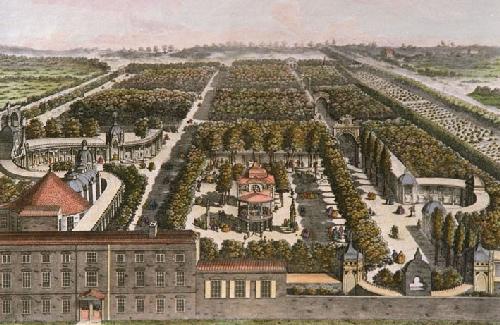
(Lower right) Wikipedia will tell you about Vauxhall Gardens, if you don't know about them already. I point them out to you for the curious structures depicted in the gardens at this date.
(The etching comes from Wikicommons. The filename is unchanged. You can get the source details by going to the WP Vauxhall Gardens entry.)
The structures shown on the map are visible in the etching.
At the right hand side of the portion of the map we are discussing on this page, you will see a huge, oddly regular hexagonal feature. That is Millbank prison. The link will take you to the Wikipedia entry which makes interesting reading. (Double-click on the small image of the plan at Wikipedia, to experience a closer look, where details emerge, which I hope you will find interesting.)
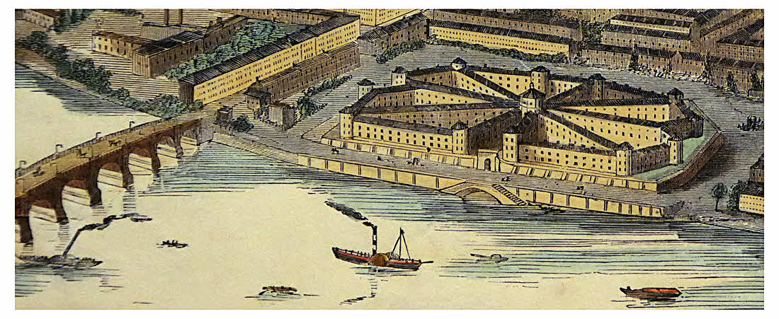
The image to the right does NOT come from Cruchley's map... but it shows you an impression of what Millbank prison looked like in 1845. (If you look closely, you will find that what is on the right does not exactly coincide with what the map and other sources show.) The image comes from a gorgeous woodcut panorama published by the Illustrated London News. My thanks to Storey's Ltd., Cecil Court, London for allowing me to bring this image to you. (If you are using this image for academic research, I should mention that I tweaked it slightly to remove unsightly "bits" of things in the river, which were only partially included in the scene.)
Opened in 1816 and closed in 1890. For such a huge structure, it seems to have been remarkably inefficient. In 1882, there were 778 inmates.. 65 inmates per floor, per "petal". Later that year a devastating epidemic swept through the facility. The site was to have been used for Jeremy Bentham's Panopticon (WP). Read about that... Stalin an Orwell would have loved it. The octagonal structure at the center is the prison's chapel. Say what you like about the Victorians, but you can't deny them their public piety!
A tiny bit of the masonry defining the moat remains, as of 2014.
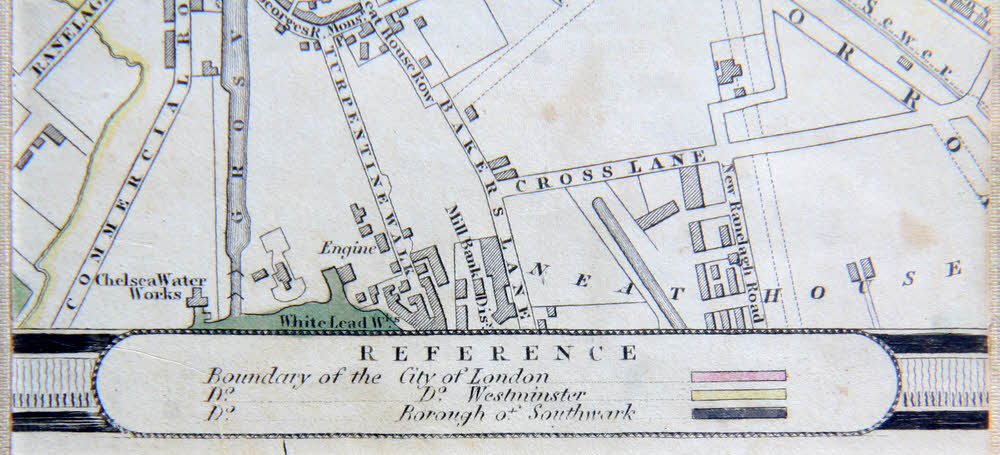
For those of you who came to my Cruchley pages for help with establishing which Cruchley map of London you have, a detail which may not fascinate others as much as it fascinates you and me...
Find the cartouche in the middle of the bottom edge saying "Reference". (That, and the others, are, of course, one very useful edition-identification resource.)
Just above the left hand end of that, you will see text:"Chelsea Water Works". Poor Mr Cruchley! He had to move that label at least three times. I hope in due course to give you images of the different positions I've seen. If you can send images of it in various places, they would be very welcome. Please document which map your images come from, though. (If the date appears in the title across the top, e.g. "Improved to 1831", that would be a Very Good Start".)
This corner of the map... 7.5 cm wide by 5 cm, out of 93 x 44... (measured inside the decorative border) illustrates nicely the sort of thing I find fascinating about this (and other) map(s)....
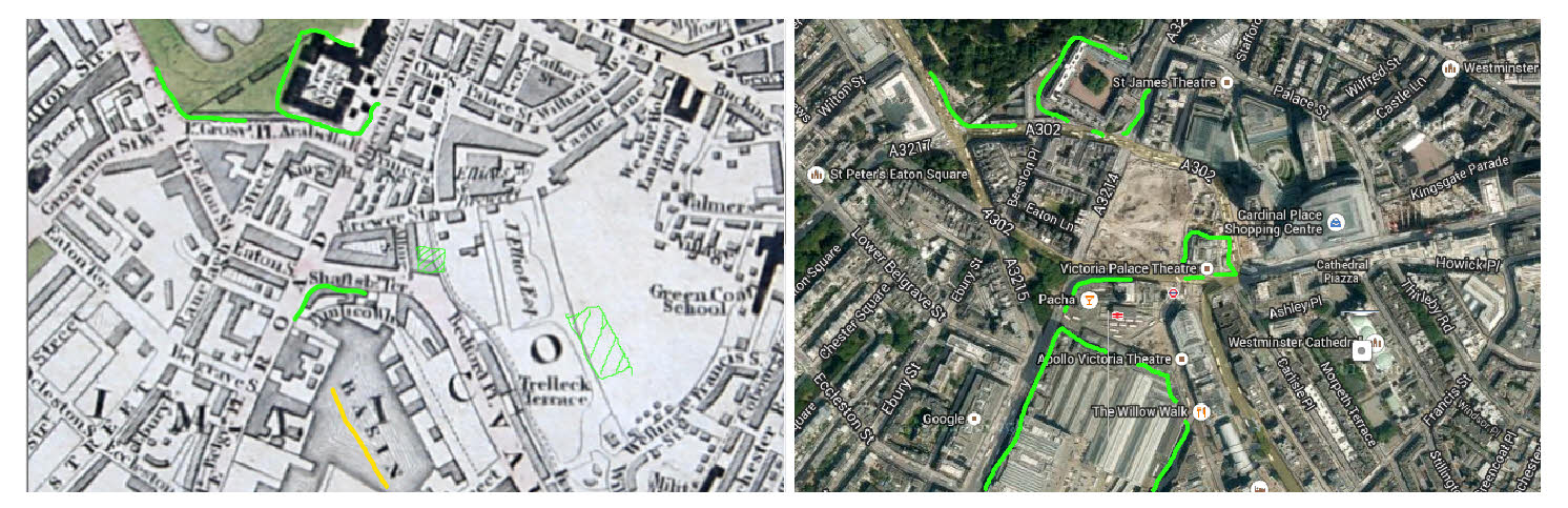
Across the top: A corner of the grounds of Buckingham Palace, and the Royal Mews.
Middle of bottom:
1830s: Basin (underlined in yellow) around 1830 (the larger map will show you that a canal connects this to the river). This basin, and the buildings around it change quite a bit from version to version of Cruchley's maps.
2014: The main concourse of Victoria's mainline station! Build over a basin! Who would have thought it. My green line encloses the terminus. If you know the area, you can see the bus depot just to the NW of my line. The trains depart to the SW, out the "back" of the station, which isn't in the image. (Cruchley's maps span the early days of trains in London. I look forward to examining ones from around 1837 when Euston (WP) opened... London's first, I think? Amazing to think that the original buildings survived into the 1960s before being swept away.
Above the basin/ Victoria Station, there is a short curved line. That is in the same place in the two images. It marked "Shaftesbury Terrace" in the old map, if I'm not mistaken, and what is now Victoria Street today.
Just past that, in the modern image, I've drawn a box around the Victoria Palace Theatre. In the old image, I've drawn a "shadow", showing where the theatre will be. Westminster Cathedral (Not the Abbey, for those unfamiliar with distinction between it and the cathedral), has been given a similar treatment.
Now! Friends of the amazing musical Billy Elliot, at the Victoria Palace Theatre... Look closely! There's an ironic coincidence present in the old map... See the bit of land belonging to J. Elliot, Esq? And just above that is "Eliots & Co, Brewery, in Brewer's Street. (Brewer's Street survived until the recent demolition of the area.) "Elliot" and "Elliott" appear on various editions of the map. So... was the modern-day "Elliot House" linked to the old brewery? (contact details below.)
More?!... At http://www.british-history.ac.uk/report.aspx?compid=22171 there's:
"At the close of the 17th century the brewery belonged to a Mr. Green, of whom nothing definite is known. Nearly a century later, in 1786, the proprietor was one Matthew Wiggins, who two years afterwards disposed of it to Edward Moore and John Elliot. This Mr. Elliot, who was an active man of liberal education, built Pimlico House, already mentioned, and used it as his town residence. He was prominently connected with public affairs in the city of Westminster, where he was held in high esteem. Sir John Call joined the firm in 1792, and somewhat later Mr. Elliot was succeeded by his son J. Lettsom Elliot. The latter took into partnership Mr. James Watney of Wandsworth in 1837, and himself retired in 1856 in favor of Mr. Watney's two sons, James and Norman. From this time the firm consisted solely of members of the Watney family until the year 1884, when Mr. James Watney, the head of the firm, died, and the business was turned into a private limited company. The fame of the Pimlico Stag ales began to spread early in the 18th century, and in 1830 the business had developed into a great and important brewery, taking rank among the first-class breweries of London."
I've seen recollections of a Stag Pub behind the Victoria Palace Theatre in pre-redevelopment times, and mention that part of the Stag Brewery was lost to Hitler's bombs. Pity to lose that, but better a bit of a brewery than the VPT!!
Another irony: The "Shaftesbury Terrace". Shaftesbury Avenue is in the heart of modern London's theatre district... about ten minutes from here, where there are a few other theatres besides the Victoria Palace. They also have good shows... but this is not "in the theatre district" as defined narrowly.
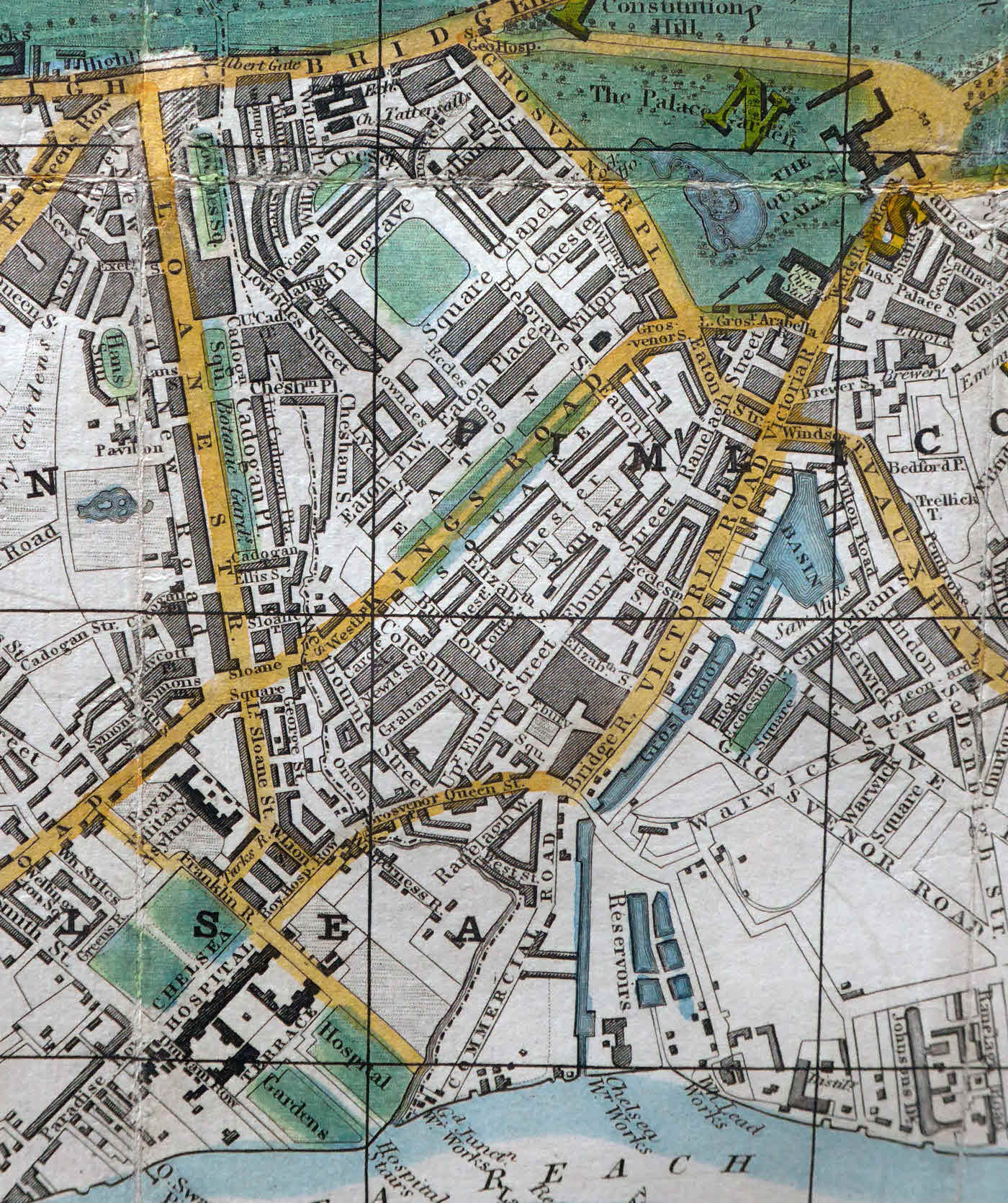
Here are some other maps of the Victoria area, from other times...
On the left, H. Martin, Reynolds Map of London, 1848 (Barely edited) Image by kind permission of Peter Harrington, London. You will see, if you look closely, Elliot & Co. Brewery is still on operation... or at least on the map!) (See the text just above these for why that is noteworthy, if you don't already know.)
On the right, Stanford, 1907 (Edited to bring two panels together) Image by kind permission of Peter Harrington, London. There's still a brewery, but now known as Stag Brewery.
Not only that tiny detail. Notice also the changes at the front of Buckingham Palace in 60 years! (And of course the loss of the basin/ gain of Victoria Railway Station!)
Remember: This is just one of the sub-pages in a collection. Near the top of my main page about Cruchley's maps of London, there are links you can click to access other pages in the collection.
Search across all my sites with the Google search button at the top of the page the link will take you to.
Or...
Search just this site without using forms,
Or... again to search just this site, use...
The search engine merely looks for the words you type, so....
*! Spell them properly !*
Don't bother with "How do I get rich?" That will merely return pages with "how", "do", "I", "get" and "rich".
I have other sites. My Google custom search button will include things from them....
One of my SheepdogGuides pages.
My site at Arunet.
This page's editor, Tom Boyd, will be pleased if you get in touch by email.
![]() Page tested for compliance with INDUSTRY (not MS-only) standards, using the free, publicly accessible validator at validator.w3.org. Mostly passes. There were two "unknown attributes" in Google+ button code. Sigh.
Page tested for compliance with INDUSTRY (not MS-only) standards, using the free, publicly accessible validator at validator.w3.org. Mostly passes. There were two "unknown attributes" in Google+ button code. Sigh.