 Bookmark this on Delicious
 Recommend toStumbleUpon
I'm afraid that I ramble a bit at the start of this, in hopes of making Cruchley "interesting". If you are already interested, and just what "the beef", fear not! In due course I get down to some specific information. While it doesn't achieve all that Howgego accomplished, I hope it will have its uses.
* Detailed observations on things around present day Victoria Station.
* A start on a system for dating and distinguishing editions.
* Notes on Cruchley's biography, including the dates he worked from various addresses.
* A small page showing the different regions covered by different versions of the map.
* How I first became aware of the Cruchley maps. (The page the link takes you to is almost trivial... but may interest personal friends, or evoke "been there, done that", feelings in fellow map lovers. Save this page for last, it is least worthy of your time.)
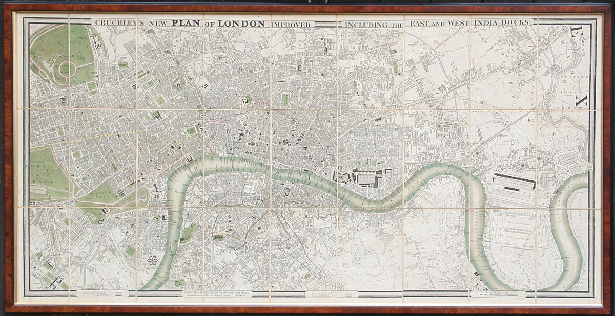
On of the reasons I love his maps is that if you study them, especially these maps by Cruchley,... magnifying glass recommended!... and think, there is a great deal in them which will bring the world of another era. The 1800s, in the case of Cruchley's maps. The Industrial Revolution is well developed, but still radically changing the physical world, and the Victorian era kicks off not long after he starts his map making Odyssey. Look at his maps with intelligence, and they will bring these things alive for you.
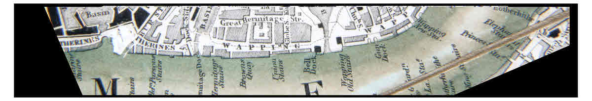
A small example: Frequently along the river, you will find named "stairs". Why? These were places where you could meet a (water) taxi, by far the nicest way in that era to get from "A" to "B", if they were anywhere near the river. Used a water taxi recently? No, I didn't think so. See what the map can tell you about?
"Old Prisoner's Stairs" doesn't sound like a place you'd want to visit... but it beats "Execution Dock", just a little further downstream from the portion shown above. (This portion of the river is just south of the great London Dock.)
In looking into what maps by Cruchley are available, I began to see that he was the king of variation.
The maps give remarkably detailed information about London, its people, its economy. And Cruchley (and, no doubt, a team organized by him) went out again and again, checked what the current state of affairs was in many corners of London, and made revisions to the maps to reflect the changes.
Not for the first time, I was made to understand that some of the Victorians were capable of prodigious enterprises. To accomplish what Cruchley accomplished today, when we have the advantages of electronic publishing would be admirable. How he accomplished it working with quill pens, copper plates, candles, is beyond my imagination.
He and his sonpublished many editions of his map. I've seen mention of one from 1827 and of one from 1857. (Cruchley Senior lived from 1796 to 1880) The information on the maps varies across time of course. And it came in various forms... hence the parts of this corner of the web, which attempt to catalogue some of the different manifestations of Cruchley's work.
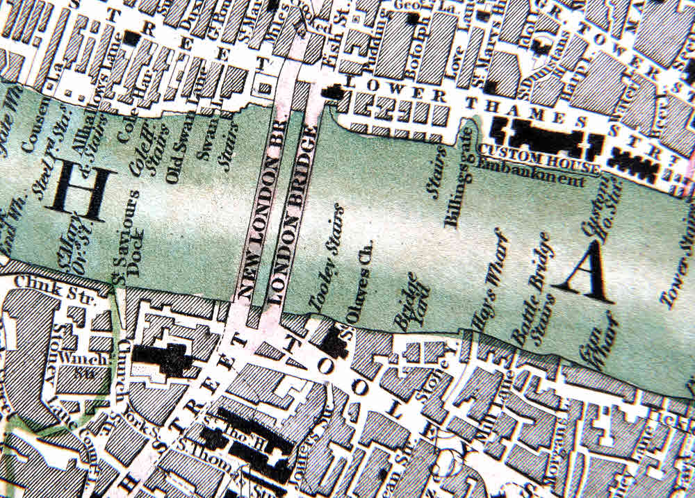
Here is a close up relating to my theme of "changing face of London". The whole map is almost exactly a meter wide by 52 cm high. This detail shows an area of 6.8cm x 5cm.
(This relates to a rather significant feature. Many of the things that change from one map to the next are "minor" details. Maybe those details are not "important", but study them to grasp Cruchley's care and industry. (Try drawing that mote of the whole map from the screen in front of you. Then draw a similar sized portion of your neighborhood in the same style. Then imagine doing the same for London from Regent's Park to Greenwich. When you've done that, remember that Cruchley's maps covered a larger region...)
But, to return to London Bridge: By the early 1800s, for almost 600 years a bridge had spanned the Thames between Southwark and The City (WP). (The Romans had one there, too, earlier.) It wasn't keeping up with the results of the Industrial Revolution. A new bridge was built alongside the old, and in 1831, it was opened. Some of Cruchley's maps show both the old and the new, later maps show just the (then) new bridge. If you are aware of any early Cruchley showing just the "old" bridge, I would be interested to hear about it.
Not only did Cruchley accomplish his amazing maps of London, but he (and his workshop) produced maps of the English counties, country maps and maps of the world. I'm told that his son followed him into the trade, so perhaps some of the work I've thought to be by Cruchley senior was by his son... but even if it was from two people, and their associates, the volume of work is stunning.
And he also wrote (and repeatedly re-wrote) a book. I've seen one edition said to have the charming title "Cruchley's Picture of London, or Visitor's Assistant. Comprising the History, Rise and Progress of the Metropolis to the Present Period, 1832".
On the title page it sometimes promises "A Route For Viewing The Whole In Seven Days"! You can get .pdfs of this, or print-on-demand facsimiles. (Or, of course, the real thing... for rather more.)
The book sometimes (often?) came with a map, presumably very similar to the discrete maps one finds available with dealers, and in archives today. Indeed some of those probably started their lives with a copy of some edition of the book.
The truly obsessive among us might want to undertake a comparison of the material in Cruchley's books and maps and those of Charles Booth, in his Life and Labour of the People In London. It seems impossible to me that the two men would have been unaware of each other.
Beware! Some of the thumbnail images at Abebooks are "squashed" to fit the standard aspect ratio. Look to see what geographical features are present, if using that source. I hope that my small page about the regions different versions covered will help you see how different the alternatives were, regardless of how similar they look in squashed thumbnails.
Remember: This is just the "homepage" for a collection of pages about Cruchley's maps. Further up the page, there are links you can click to access other pages in the collection.
Search across all my sites with the Google search button at the top of the page the link will take you to.
Or...
Search just this site without using forms,
Or... again to search just this site, use...
The search engine merely looks for the words you type, so....
*! Spell them properly !*
Don't bother with "How do I get rich?" That will merely return pages with "how", "do", "I", "get" and "rich".
I have other sites. My Google custom search button will include things from them....
One of my SheepdogGuides pages.
My site at Arunet.
This page's editor, Tom Boyd, will be pleased if you get in touch by email.
![]() Page tested for compliance with INDUSTRY (not MS-only) standards, using the free, publicly accessible validator at validator.w3.org. Mostly passes. There were two "unknown attributes" in Google+ button code. Sigh.
Page tested for compliance with INDUSTRY (not MS-only) standards, using the free, publicly accessible validator at validator.w3.org. Mostly passes. There were two "unknown attributes" in Google+ button code. Sigh.