This page is a sub-page off of my pages about Cruchley's maps. Even if this page is of limited interest, I hope you will visit the main pages.
This page focuses on distinguishing one Cruchley from another, and is probably only of interest to collectors confronted with "what's this one??". I have done a more general page in hopes of infecting you with the excitement I get from pouring over the Cruchley maps.
Editions of Cruchley's maps
I don't expect to achieve all that Howgego accomplished. But I still hope this will have its uses. (Howgego is a frequently cited authority.)
Revisions....
In looking into what maps by Cruchley are available, I began to see that he was the king of variation.
As a "first cut", I will group the editions according to how they were printed, i.e. how many panels made up the map, and some related parameters. I will write a separate page explaining how to interpret my codes for this information.
The heart of the "code" will be two numbers. An edition of the map which was printed as 9 columns of panels, with 3 rows of panels in each column will be a "09x3" map. (The leading zero is a computer-centric thing I have explained on the separate page which goes into the details of the codes I will be using to catalogue specific maps. There will be two codes, which between them will concisely tell you much about the panels the map is made from, the limits of the region the map protrays, and the scale at which it was drawn.)
Also to come on the separate page, details of a second pair of "row and column" numbers. Those numbers will tell you where, in the overall scheme of the map in question, you can find the panel with St. Paul's cathedral on it.
The idea is to have a "code" which be determined from even a low resolution image of a map, which will "divide" the problem of identifying an edition, and thus help us conquer it!
The code will tell us a lot about the dimensions of the map, and the area of London and its environs covered by it.
Dates
In a perfect world, every map would have (an accurate) statement on it of when it was printed. Of course, that still leaves open the question of how up to date the information on the map is, but we'll leave that problem for another time.
Cruchley often... thankfully... but not always put a date on is maps, frequently in the title across (typically) the top of the map.
So not only can we... up to a point... sort his maps by the panels they are made from, but also by their dates.
Where a date is not present on the map, various things help us make a guess, and we will use those to assign our best guess to the maps in this list of Cruchley's editions.
Beware! Some of the thumbnail images at Abebooks are "squashed" to fit the standard aspect ratio. Look to see what geographical features are present, if using that source. Maps that look the same width may not be.
Dating/ Edition Identification Points
Dating points arising from text
There are numerous clues in the text in the cartouches around the borders of the maps. I will attempt to systematize the use of that text in due course. For now, I will just mention that probably the text relating to where a given map was published, or may be obtained, is going to be a useful resource for dating.
Mention of "Arrowsmith" is probably restricted to early maps.
Further dating points
For convenience, I am setting up a system of abbreviations. Each will end "-dptkb" for "Dating Point, by tkb", "tkb" being my initials. Call me vain... but this will also help to distinguish THESE dating points by any which another bibliographer may devise.
For each dating point, there will be a discussion of known variants, and a list of abbreviations to use in saying which variant a given map exhibits.
Where a map has a date on it, you might think that recording the dating point variants is irrelevant... but if we compile a list of the dating points present on maps with dates printed on them, the state of the dating points without a printed date should help us to date the date-less maps, no?
LdnBrdg-dptkb
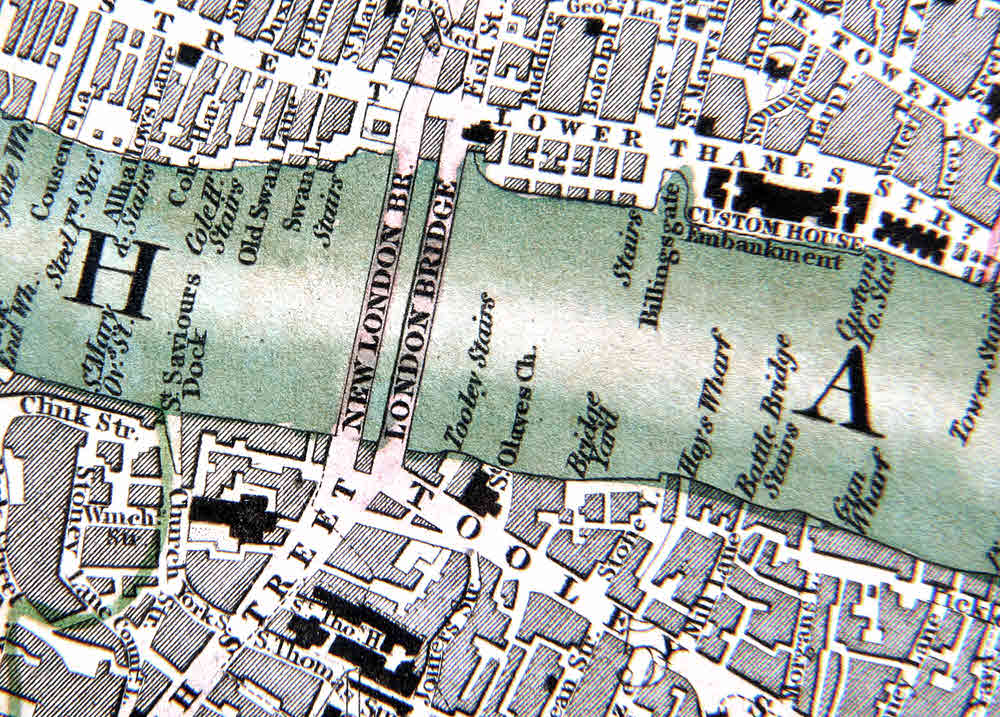
The whole map this is taken from is almost exactly a meter wide by 52 cm high. This detail shows an area of 6.8cm x 5cm.
There's been a bridge there since Roman times, and for centuries it has been known as "London Bridge". (The more often photographed bridge is, of course, Tower Bridge. Did the person from the USA who bought the old one really think he was buying Tower Bridge, as wags have suggested?)
Some of Cruchley's maps show both the old and the new. I don't believe he did a map early enough to show just the old bridge, but, just in case, we'll set up our abbreviation for this dating point as follows:
LdnBrdg-dptkb:o
LdnBrdg-dptkb:on
LdnBrdg-dptkb:n
The first says "Only old bridge on map". The second says "Old and new bridges on map". The third says "Only new bridge on map".
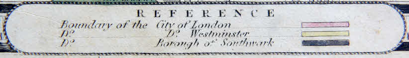
ChelWatWrks-dptkb
Pretty well straight south from Buckingham Palace, on the north bank of the Thames, there was the Chelsea Water Works.
The water works seems to have been a bit of a hassle for poor Cruchley- he revised, and revised, and revised again the placing of his label for them. Which is bad for him... but good for our wants in trying to distinguish editions!
I don't as yet have a system of codes for the various appearances of the label, but one will come in due course.
The image above comes from an undated map (type 09Vx3/4p2,11x16s122) with both London Bridges on it. I will try to add examples of other variants soon... I am awaiting permission to use other people's work.
The distillery near the center of the bottom of the image above is also worth checking. The name changes at least three times.
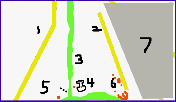
When I can't publish an image from a map, I may be able to publish a sketch of things I've seen in the area. Such sketches will be based on what you see above. Elements of that were dynamic, but the rough position of the river and canal (green) and roads (yellow) make a starting point. (Working on depicting this tiny region, like this, enhanced my grasp of the difficulties experienced by Cruchley!)
((MORE DATING POINTS TO COME))
Details of some specific maps
TO COME....
((preface explaining:Ordered by date (define date determination rules)), general form for each entry, incl source/authority, and that table of highlights follows... then do both!))
Individual maps analysed
This section is in draft form... subject to format revision
((individ maps, by date, as far as poss, with uncertainties highlighted))
1827 Type 09x3/4p2
TKB ID: m14a13b
This is just a "stub" for this map for the moment... but I couldn't resist a few brief observations, as it is the earliest version of the map known to me at this point.
Top edge: It does, explicitly, say "... Improved to 1827..."
Bottom edge, second cartouche: Very nearly as in f14a09a..."Engraved & Published by G.F.Cruchley. Map-Seller./(from Arrowsmith's) 38 Ludgate Street.___ London."... but with "1927" added to the end of the second line. While examining this cartouche, I noticed that both cartouche and the map elements above it were displaced very slightly (about 2mm, at the scale of f14a09a) to the right. By "displaced", I mean that the break across the panel occurs in a different place. I checked the break for another panel, and found the same displacement. Were the plates used for printing the map larger than one panel, and then the printed sheets cut up for mounting on the linen, for folding? That would explain such a slight displacement easily enough. Between this map (m14a13b) and f14a09a the difference in where the horizontal panel boundaries lie is, in at least one instance, pronounced... 8mm.
Buckingham Palace, as we know it today, is labelled "Buckingham Ho.", behind it is "Queen's Gardens", and the pond is a small oval, the long axis running N/S, and being about 1.1x the length of the diagonal of what is called "New Kings Mews", then as now in the southern corner of what was called Queen's Gardens.
The basin where modern day Victoria Station is is depicted slightly differently in this map vs. map f14a09a (see below). But "Brewer St", and the two references to "Elloit" are present.
The river end of the canal is similar to that in m14a13a, but the label "Chelsea Water Wrks" is placed slightly to the left, bringing it to the right hand edge of the odd "thing" I thought might be a pond.
LdnBrdg-dptkb:on
Early 1829? Type 09x3/4p2,11x16s122
TKB ID: f14a09a
Date of this map uncertain, so position in list subject to change.
Top-of-page title, all of the text on top edge. In two cartouches, text split where "/" appears...
"Cruchley's New PLAN of LONDON Improved / Including The East and West India Docks"
Text in cartouches along left or right edges:none.
Text in cartouches along bottom edge: Four cartouches. ("/" signifies new line within cartouche, "//" signifies new cartouche).
First (left hand) cartouche, bottom edge.
.
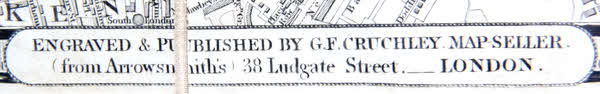
Second cartouche, bottom edge. Says: "Engraved & Published by G.F.Cruchley. Map-Seller./(from Arrowsmith's) 38 Ludgate Street.___ London."
This particular bit of text (above), or its equivalent, is a particularly useful indicator of a map's date or edition, and should be watched for. (In due course, when I have a better feel for the variations, I will set up a standard "-dptkb" item for this text.)
.
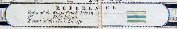
Third cartouche, bottom edge. Says "Reference / Rules of the Kings Bench Prison /... etc". The slang expression "in clink" (for incarcerated in prison) stems from something related to the last line, "Extent of the Clink Liberty". "The Liberty" is an interesting story you can look up, or I will try to get to someday.
.
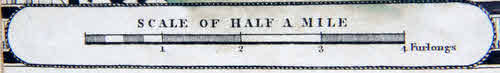
Fourth and last cartouche, bottom edge. Says "Scale Of Half A Mile / Furlongs". The bar is 61mm long.
Buckingham Palace, as we know it today, is labelled "The Kings Palace", and has a fine geometric garden on it's north side... but just that. (See notes in text about m14a13a, 1929, which is, I believe, a later map.) Behind (to the SW) are the "Palace Gardens", and the pond is complex, the long axis running from NW to SE, and being about twice the length of the diagonal across what is called "New Kings Mews" (text in the building's quadrangle), then as now in the southern corner of the palace gardens.
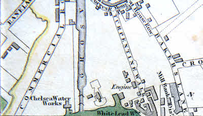
ChelWatWrks-dptkb:See image to the right. Chelsea Water Works label to west of canal, horizontal, "Chelsea Water//Works". Distillery known at this time as "Mill Bank Disy".
LdnBrdg-dptkb:on
1829 Type 09x3/4p2
TKB ID: m14a13a
I would guess that this map is also of sub-type 11x16s122, but that is based on impressions of an image, not actual measurements. The appearance of the cloth backing was a major factor in my guess.
Top-of-page title, all of the text on top edge, all in one cartouche...
"Cruchley's New PLAN of LONDON Improved To 1829 Including The East and West India Docks"
Text in cartouches along left or right edges:none.
Text in cartouches along bottom edge: ("/" signifies new line within cartouche, "//" signifies new cartouche).
Text in cartouches along bottom edge: Appears to be the same as in map f14a09a. (See above, at the moment, as "early 1829?".. but that may move... please let me know if you find that f14a09a has been moved or given a different date.
Four cartouches. THESE IMAGES ARE NOT FROM m14a13a... but, to me, looking at an image of m14a13a, its cartouches appeared the same. See f14a09a for comments on the cartouches.
First (left hand) cartouche, bottom edge.
.
Second cartouche, bottom edge.
.
Third cartouche, bottom edge.
.
Fourth and last cartouche, bottom edge. The bar is 61mm long on f14a09a. I don't know how long it is on m14a13a, but, from clues in things like the appearance of creases, the cloth of the backing, I would GUESS that is is the same.
Buckingham Palace, as we know it today, is labelled "The Kings Palace", and has a fine geometric garden on it's north side, and two radial pattern gardens to the west of them. (This is, 13Oct14, my basis for saying that the undated f14a09a is from before this map, before m14a13a.) Behind (to the SW) are the "Palace Gardens", and the pond is complex, the long axis running from NW to SE, and being about twice the length of the diagonal across what is called "New Kings Mews" (text in the building's quadrangle), then as now in the southern corner of the palace gardens.
ChelWatWrks-dptkb...
Hmmm... I hope I can get permission to publish a screenshot of this region. For now, my feeble diagram and words will have to suffice.
Overall, this corner of the map, at this stage, is not very far developed!
1: What is sometimes marked Commercial Road present, but without label.
2: Label for Turpentine Lane along side it,to left of lane.
3: Lable for "Canal" along side it, to right.
In region below where I have my labels, and between the two roads, remarkably few buildings. Such buildings as there are (crudely!) depicted in red.
4: The "I" is only an outline. My guess? A man made pond of some sort. This object is sometimes marked "Chelsea Water Works", hence my guess at "pond". There is a filled in small square in the middle of it (shown in red). A pumphouse, or similar? (It is similar to the outline shown in the image from map f14a09a. (Above... when I wrote this, at which time it was thought be from before the present map, due to the state of the Buckingham Palace Gardens. However: The building inside the "outline" was smaller in the present map, suggesting that maybe it is the older of the two. Sigh.)
5: Above and to the left of the building, the text "Grd Junction/Water Wrks" (new line where you see "/"). Where the three dots are, on that line, "Lock". (Text horizontal, unless otherwise stated.)
6: "Chelsea/ Water Wrks". Just east of them, across the road: "White Lead Ma..." (I can't make out all of the text. It is on a slight up-to-right slant.)
7: While in general, you shouldn't assume anything about items not explicitly discussed, in this case, I want to say explicitly: Make no assumptions about what is in the region shaded gray. Baker's Lane is labeled, but doesn't run quite as the yellow sketch line hidden by the grey would suggest.
LdnBrdg-dptkb:on
Table of Maps... to come
((table of maps))
Remember: This is just one of the sub-pages in a collection. Near the top of my main page about Cruchley's maps of London, there are links you can click to access other pages in the collection.
The search engine merely looks for the words you type, so....
*! Spell them properly !*
Don't bother with "How do I get rich?" That will merely return pages with "how", "do", "I", "get" and "rich".
Ad from page's editor: Yes.. I do enjoy compiling these things for you... I hope they are helpful. However.. this doesn't pay my bills!!! If you find this stuff useful, (and you run an MS-DOS or Windows PC) please visit my freeware and shareware page, download something, and circulate it for me? Links on your page to this page would also be appreciated!
Page tested for compliance with INDUSTRY (not MS-only) standards, using the free, publicly accessible validator at validator.w3.org. Mostly passes. There were two "unknown attributes" in Google+ button code. Sigh.
 Bookmark this on Delicious
 Recommend toStumbleUpon